La Niña is set to shape Australia’s summer 2021-22 with above-average rainfall forecast for eastern parts of the continent; elevating flood risks. Most of Australia, except in parts of the southeast, should expect above average maximum summer temperatures.
This explainer distils the latest advice from the Bureau of Meteorology on what to expect this summer. It takes stock of extreme weather risks, takes a close look at the impact of La Niña – the dominant climate driver affecting our weather now – and puts it all in the context of our changing climate.
What is La Niña, and how is it shaping the 2021-22 summer in Australia?
The Bureau of Meteorology declared that a La Niña is underway on November 23, 2021. Australia’s weather is influenced by a number of “climate drivers”, including the El Niño Southern Oscillation, Indian Ocean Dipole, Southern Annular Mode and Madden-Julian Oscillation. These are cyclical fluctuations in ocean surface temperatures and ocean-atmosphere interactions in the Pacific Ocean, Indian Ocean, Southern Ocean and the tropics respectively. They influence year-to-year variations in temperature, rainfall and other weather patterns.
La Niña is one phase of the El Niño Southern Oscillation. It occurs when equatorial trade winds become stronger; bringing cooler water up from deeper in the ocean. This results in a cooling of the surface of the central and eastern tropical Pacific Ocean. The stronger trade winds also help warm surface water accumulate in the western Pacific and to the north of Australia. These warmer waters in the western Pacific mean more clouds develop as warm, moist air rises. This can result in heavy rainfall to the north of Australia.
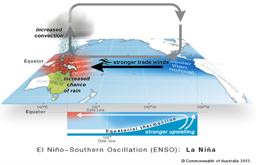
Every La Niña event is different, as the effects of La Niña may be amplified or dampened by the other climate drivers.
The current La Niña is expected to persist until late summer or early autumn 2022. However, there are reasons to expect that this La Niña will not be as disruptive as the exceptionally strong event of 2010-12, including the fact that the 2010-12 La Niña coincided with a negative phase of the Indian Ocean Dipole. This tends to amplify the effects of La Niña. Right now, the Indian Ocean Dipole is in a neutral phase.
But the Southern Annular Mode (SAM) is forecast to remain at positive levels to the end of the year. La Niña conditions in the Pacific Ocean, and the positive SAM phase are influencing the above average rainfall outlooks. See BoM’s latest ‘Climate Driver Update’ for more information.
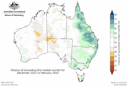
According to the Bureau of Meteorology’s December to February (summer) outlook , and consistent with typical La Niña conditions, rainfall between December to February is likely to be above average for eastern Australia, particularly eastern parts of Queensland.
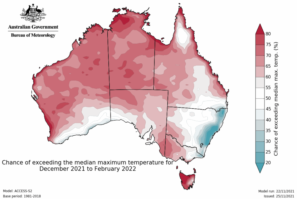
The odds are stacked (1.5 to 3 times more likely) in favour of some unusually high maximum temperatures for most of the country away from the southeast. Below average daytime temperatures are likely for eastern NSW.
What extreme weather risks are we looking at this summer?
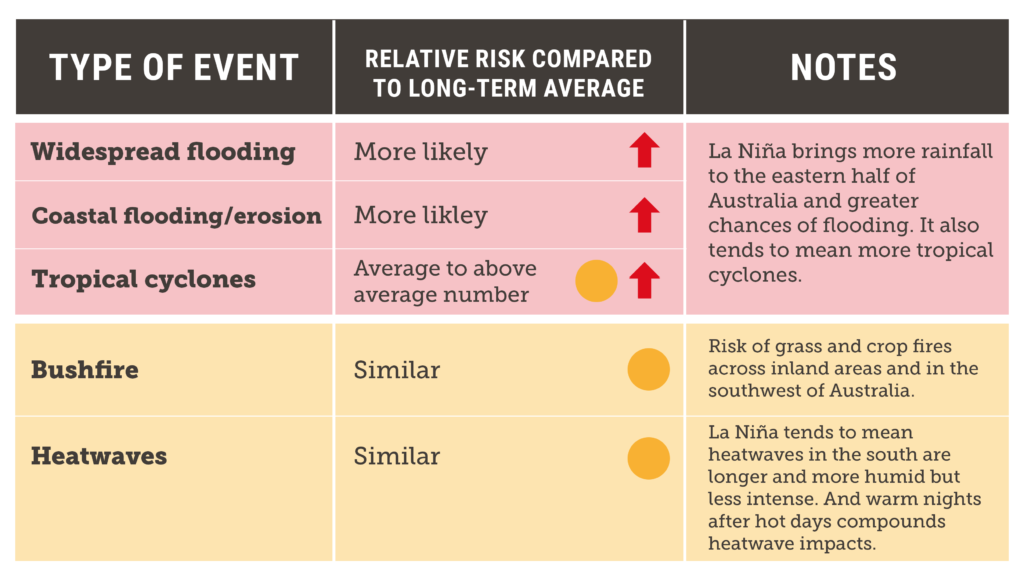
The Bureau of Meteorology’s Summer Outlook 2021-22 shows it is likely to be wetter than average for eastern parts of the continent, with higher risk of heavy rainfall and widespread flooding for these areas.
When it comes to cyclones, during La Niña years there are typically more cyclones in the Australian region than during non-La Niña years. During the 2010-12 La Niña there were several notable cyclones, including Cyclone Yasi – one of the strongest and costliest in Australia’s history. Every year in which there have been more than one severe landfalling tropical cyclone in Queensland was a La Niña year. The Bureau of Meteorology has predicted an average to slightly-above-average number of cyclones for the 2021-22 season.
What does this mean for bushfire risks?
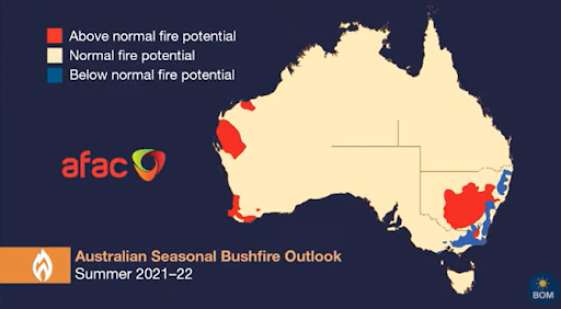
Above-average rainfall may seem like good news when it comes to reducing bushfire risks. However, rain in spring and early summer means lots of grass growth. If these grasses dry out quickly in the warm weather, the risk of fast-running grass fires increases.
The Bureau of Meteorology has warned that over summer 2021-22 we need to be mindful about grass and crop fires, particularly across inland areas and in the southwest of the country where we have had high grass growth over winter and spring.
All in all, 2021-22 is unlikely to see a repeat of the horrendous conditions we experienced in the lead up to and during the Black Summer, although we must not be complacent. Sadly, due to accelerating climate change, we have entered a new era of greater fire risk and must be even more vigilant than before.
How does it all relate to climate change?
While the La Niña event will influence our weather this summer, it is important to remember that these short-term cyclical drivers are now occurring in the context of a warming climate.
Australia’s temperature and rainfall variability are also influenced by global warming caused by human activities, primarily the burning of coal, oil and gas and land use changes like deforestation. All weather now occurs in an atmosphere that is warmer, wetter and more energetic. Australia’s climate has warmed by around 1.44°C between 1910 and 2019. A warmer atmosphere can hold more water vapour – seven percent more for every degree of warming. A warmer and wetter atmosphere also provides more energy for weather systems that generate intense rainfall. This means that while climate change may only result in a modest increase in the overall amount of rain globally – limited by the moisture holding capacity of the atmosphere – it’s leading to a dramatic increase in the heaviest and most damaging rainfall events. In recent decades, and especially across northern Australia, a greater proportion of our rain is coming in the form of short, intense downpours. This trend is set to continue, and increases the risk of dangerous floods.
Ignoring climate change is costly
Australians are already paying the price for the carbon pollution that’s been added to the atmosphere over the past two centuries.
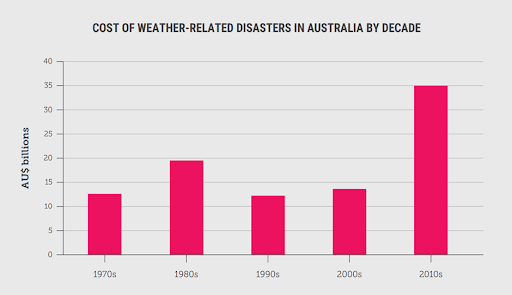
The cost of extreme weather disasters in Australia has more than doubled since the 1970s, reaching $35 billion for the decade 2010-2019. Queensland bears the highest burden with the state’s total losses from extreme weather disasters since the 1970s around three times those of Victoria, and about 50% greater than NSW. On a per person basis, Queensland’s losses were more than twice the national average.
For more information, see the Climate Council report, ‘Hitting Home: The Compound Costs of Climate Inaction’.
Governments, like the Australian Government, that failed to reduce emissions over the past decade have sentenced Australians, and communities worldwide, to a far more dangerous future than if they had heeded repeated warnings from scientists. Due to this past inaction, gradual, measured steps are no longer enough to avoid catastrophe. At this point, truly transformative action is required. That means at least halving global emissions over the coming decade and reaching net zero emissions globally by 2040 at the latest. Australia, as a developed country with abundant potential for renewable energy, should aim to reduce its emissions by 75% by 2030 and reach net zero by 2035.
No developed country has more to lose from climate change-fuelled extreme weather, or more to gain as the world transforms to a zero-carbon economy, than Australia does. It is in all of our interests to do more to cut emissions, urgently and rapidly.
For more information, see ‘Aim High, Go Fast: Why Emissions Need to Plummet this Decade’ which is the Climate Council’s science-backed vision for what Australia’s best effort could look like.
Stay Safe this Summer
Stay safe everyone, and if you haven’t already done so, check your state/territory’s fire and emergency agency for advice on how to manage the summer’s extreme weather risks.