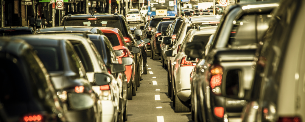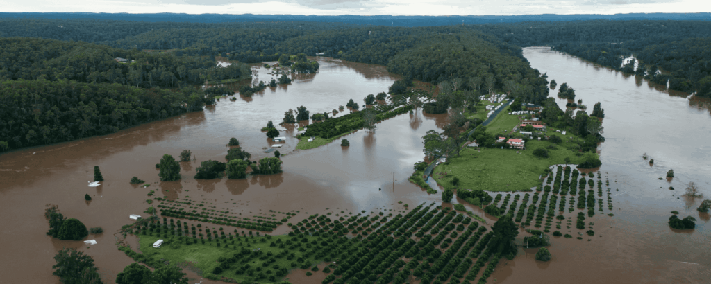
Climate impacts are endangering all Australians, but some communities are highly exposed and face far greater risks today. Climate Council analysis finds more than two million properties across Australia are already at moderate to high risk of worsening extreme weather driven by climate pollution.
Our research identifies the top ten electorates, where properties are at high risk* of catastrophic damage because of our failure to drive down climate pollution, which is supercharging more destructive extreme weather events.
Which Federal Electorates are at highest risk?
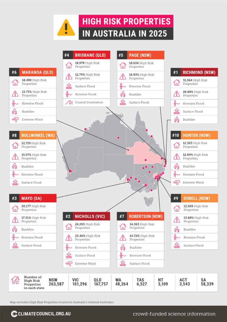
1. Richmond, New South Wales

The seat of Richmond includes famous coastal tourism destinations like Byron Bay and Brunswick Heads, as well as Tweed Heads and Murwillumbah (AEC 2025a).
Many of the communities across the electorate are facing extreme weather events made worse by climate pollution. Our analysis shows: 31,564 or 28.9% of properties are already at high risk, with riverine flood, surface flood and bushfire the main climate risks. Across all properties it is estimated there has been a 4% increase in average risk of damage from climate extremes (1990-2025).
Tweed, Byron and Ballina are at risk of tropical cyclones, while Tweed and Ballina have a higher risk of flood to their built environments than any other local government areas in New South Wales, except for Clarence Valley (NSW Reconstruction Authority 2024).
On high levels of climate pollution (RCP 8.5/ SSP5-8.5), the average risk of damage from climate extremes is projected to increase by 158% (or a 2- 3-fold increase) by the end of the century.
2. Nicholls, Victoria

Known as a gateway to the waters of the Murray River via Echuca and Yarrawonga in the north and for wineries to the south in towns like Nagambie, Nicholls takes in many picturesque towns across northern and central Victoria.
Many of the people living here have experienced the impacts of climate-fuelled disaster firsthand, with the towns of Echuca, Shepparton, Mooroopna and Seymour hit by devastating floods in 2022 (Parliament of Victoria 2024).
Our analysis shows: 26,055 or 25.5% of properties are already at high risk, with riverine flood, surface water flood and extreme wind the main climate risks. Across all properties it is estimated there has been a 20.5% increase in average risk of damage from climate extremes (1990-2025).
Risk of damage from climate extremes in Nicholls is modelled to increase 8.4% between now and the end of the century.
3. Mayo, South Australia

The rural electorate of Mayo takes in the Fleurieu Peninsula and Kangaroo Island, areas famed for their wineries, beaches and native vegetation.
Mayo was heavily impacted by the Black Summer bushfires in 2019-20, with Kangaroo Island bearing the brunt of catastrophic fires (ELCA and Climate Council 2024). More recently, communities across the Fleurieu Peninsula have been on tenterhooks as many towns have gone more than 100 days without sufficient rainfall.
Our analysis shows: 20,177 or 17.5% of properties are already at high risk, with bushfire the main climate risk, followed by riverine flood and surface flood. Across all properties it is estimated there has been a 20.8% increase in average risk of damage from climate extremes (1990-2025).
Risk of damage from climate extremes in Mayo is modelled to almost double (up 83%) between now and the end of the century.
4. Brisbane, Queensland

Covering the Central Business District and inner-city areas such as Fortitude Valley, New Farm and Newstead, the electorate of Brisbane is at the centre of Australia’s third largest city.
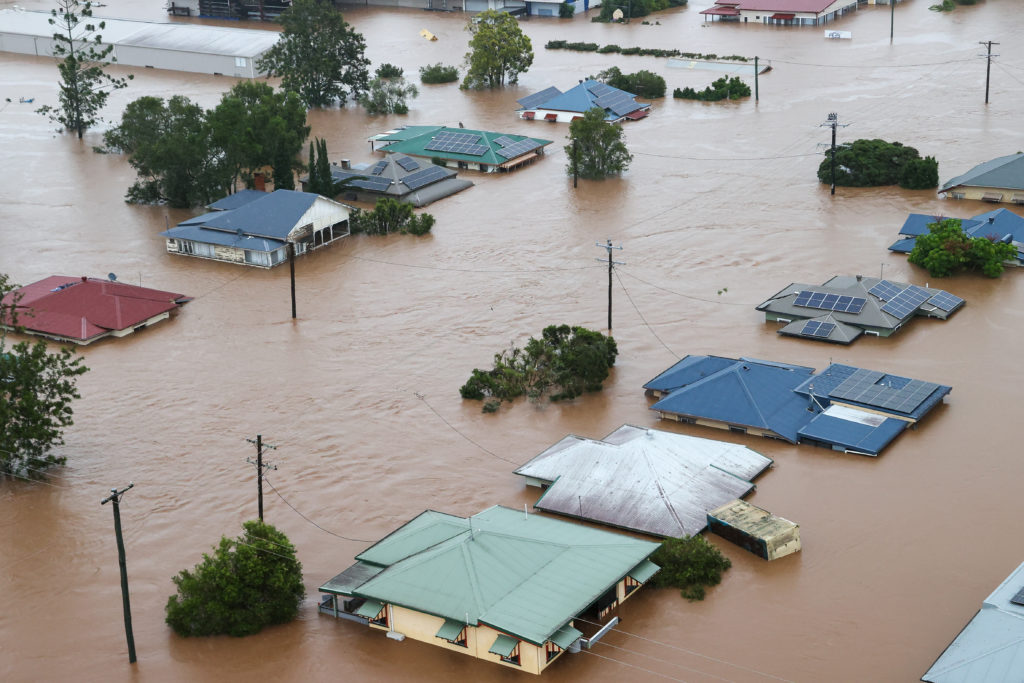
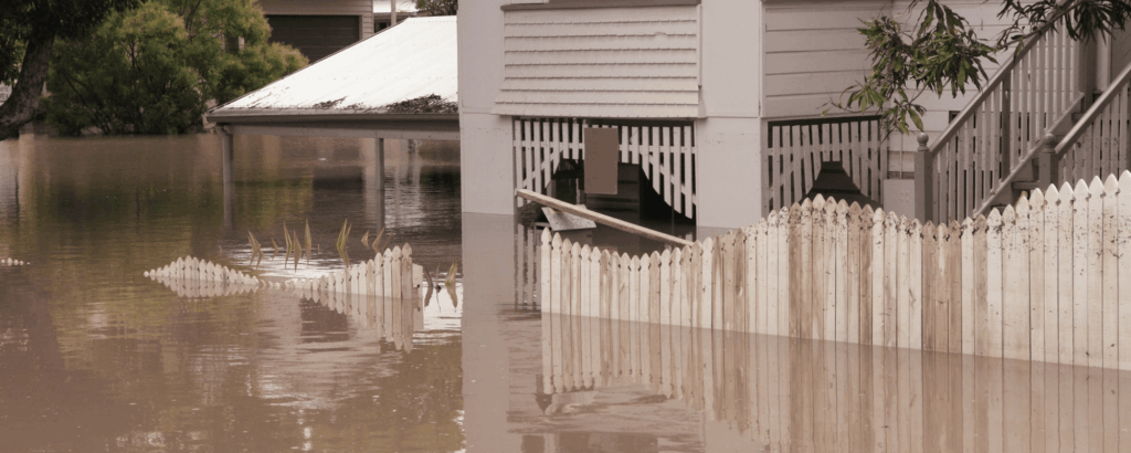
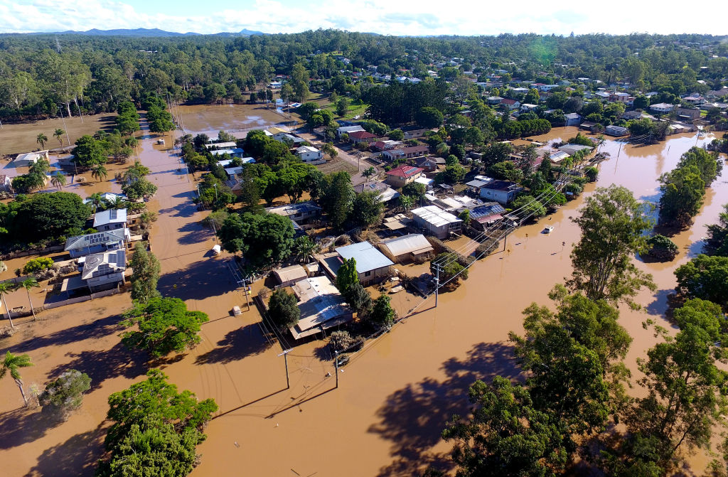
Being built on a flood plain around the Brisbane River places the electorate and city at great risk of flooding when heavy rainfall and or storm surge strikes (Brisbane City Council 2023; Cook 2025). During the 2022 floods, at least 179 suburbs were impacted across the Greater Brisbane City (Brisbane City Council 2022).
Our analysis shows: 18,978 or 12.7% of properties are already at high risk, with surface water flood, riverine flood and coastal inundation the main climate risks. Across all properties it is estimated there has been a 36.3% increase in average risk of damage from climate extremes (1990-2025).
Risk of damage from climate extremes in Brisbane is modelled to increase by 64.8% between now and the end of the century.
5. Page, New South Wales

Taking in beautiful coastlines and scenic hinterland, the electorate of Page is also home to some of the most disaster-prone communities in New South Wales (ELCA and Climate Council 2024; NSW Reconstruction Authority 2024). The local government area of Clarence Valley is one of the most disaster impacted in the state, based on historical disaster recovery funding arrangement activations, while Lismore was severely impacted by successive floods in 2022 (ELCA and Climate Council 2024).
Our analysis shows: 18,636 or 16.9% of properties are already at high risk, with riverine flood, bushfire and surface water flood the main climate risks. Across all properties it is estimated there has been a 7.3% increase in average risk of damage from climate extremes (1990-2025).
Risk of damage from extreme weather in Page is projected to increase by 69.6% between 2025 and 2100.
6. Maranoa, Queensland

Stretching from the outer suburbs of Brisbane and the Gold Coast to the Northern Territory and South Australian borders, Maranoa is almost three times the size of the United Kingdom but is home to less than .002% of Australia’s population.
Parts of the electorate were devastated by bushfire in 2023-24, when Queensland experienced a fire season where more houses were lost in that state than during all of Black Summer (ELCA and Climate Council 2024). The town of Tara, Western Downs was at the centre of the devastation, where 20,500 hectares were burnt, and more than 300 people had to evacuate (Response 2023; Queensland Reconstruction Authority 2024).
In March 2025, communities in the Maranoa electorate were badly impacted by flooding – the largest recorded in the state’s history (The Guardian 2025).
Our analysis shows: 18,499 or 13.7% of properties are already at high risk, with riverine floods, bushfire and extreme wind the greatest climate risks. Across all properties it is estimated there has been a 10.4% increase in average risk of damage from climate extremes (1990-2025).
Risk of damage from climate extremes in Maranoa is modelled to increase 42.3% by the end of the century.
7. Robertson, New South Wales

Taking in parts of NSW’s Central Coast, Robertson includes the waterways of Broken Bay and Brisbane Waters, and famous beaches such as Umina, Avoca Beach and Terrigal.
Households and businesses in Robertson are already facing a number of climate risks. Large parts of the area are forested, with many households backing on to bushfire prone areas. At the same time, others are located close to beaches and estuarine areas that may experience coastal erosion and inundation (NSW Government 2024).
Our analysis shows: 14,063 or 14.72% of properties are already at high risk, with bushfires, riverine flood and surface water flood the main risks. Across all properties it is estimated there has been a 26.9% increase in average risk of damage from climate extremes (1990-2025).
Risk of damage from climate extremes in Robertson is modelled to more than double (132.6%) by the end of the century.
8. Bullwinkel, Western Australia

Home to Kalamunda’s Big Bobtail Blue tongue lizard monument, the newly created electorate of Bullwinkel sits on the outer boundary of Perth’s metropolitan area. Large parts of the electorate are in bushfire prone areas (DFES 2025).
Our analysis shows: 12,719 (15.6%) of properties are already at high risk, with bushfire, riverine flood and surface water flood the main climate risks. Across all properties it is estimated there has been a 36.8% increase in average risk of damage from climate extremes (1990-2025).
Risk of damage from climate extremes in Bullwinkel is modelled to increase more than four-fold (313.7%) by the end of the century.
9. Dobell, New South Wales

With trendy Long Jetty and the popular family holiday hot spot The Entrance, the Dobell electorate takes in the northern parts of the Central Coast in New South Wales.
Much like the neighbouring electorate of Robertson, residents of this part of the Central Coast are exposed to a number of risks, including bushfire in the hinterland, and coastal erosion and inundation around inlets and coastal beaches (NSW Government 2024).
Our analysis shows: 12,569 or 13.88% of properties are already at high risk with bushfire, riverine flood and surface flood the main climate risks. Across all properties it is estimated there has been a 22.2% increase in average risk of damage from climate extremes (1990-2025).
Risk of damage from climate extremes in Dobell is modelled to more than double (up 144.5%) by the end of the century.
10. Hunter, New South Wales

Taking in the western shore of Australia’s largest salt water lake at Lake Macquarie, the Hunter electorate is largely rural, with the majority of the population living outside of major or regional cities (AEC 2024d)
Situated on the banks of the Hunter River, the regional centre of Singleton has experienced a number of floods over the decades. The town just marked the 70th anniversary of the devastating 1955 flooding that led to 14 people losing their lives (Singleton Council 2025; Wakatama and Lewis 2025). The town was also inundated by flood waters in July 2022 (SMH 2022).
Our analysis shows: 12,363 or 12.84% of properties are already at high risk, with bushfire, riverine flood and extreme wind the main climate risks. Across all properties it is estimated there has been a 32.52% increase in average risk of damage from climate extremes (1990-2025).
Risk of damage from climate extremes in Hunter is modelled to almost double (89.2%) by the end of the century.
*The top ten electorates at risk are based on the percentage of properties that are classified as ‘highrisk’.
High Risk Properties are defined as properties where there is a significant risk of insurance becoming unaffordable or withdrawn entirely due to the high risk of damage from extreme weather. Properties are considered ‘high risk’ when the Maximum-to-date Value-At-Risk (MVAR) attributed to it is equal to or over 1% MVAR.
Want to learn more about how climate change impacts Australian communities?
Our report, At Our Front Door, finds over 2 million homes and businesses are at high or moderate risk today from worsening extreme weather driven by climate pollution. homes and businesses are the suburbs across Australia where properties face the most acute risk from climate-fuelled extreme weather events.